A view of the Earth that’s rarely seen
The newly revamped Google Earth showcases the planet’s most stunning sights from above, turning both natural and man-made landscapes into colourful works of art.
Don’t look closer to find beauty in the ordinary – look farther. It’s no secret that the Earth is teeming with stunning sights, but a view at the planet from way up high makes one question whether it is art that mimics nature or vice versa.
Through stunning satellite images, the newly revamped Google Earth allows people to uncover hidden gems around the globe and see our planet from a new perspective. Scenes that may seem unremarkable from the ground explode in bleeding hues, abstract shapes and vibrant colours when seen from outer space. A closer look reveals a beautiful world to explore down below.
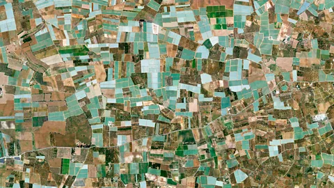
The province of Bari is an important commercial centre in southern Italy – its namesake capital is second only to Naples in terms of economic activity. The old lives alongside the new in the city, which is home to heritage sites such as 12th Century Castello Normanno-Svevo and the Basilica di San Nicola, as well as the modern Karol Wojtyla Airport and the acclaimed University of Bari Aldo Moro. Vistors can explore the narrow streets and medieval architecture of Bari’s Old Town and then experience the city’s hip nightlife.
From above, Bari’s landscape resembles one of French artist Paul Cezanne’s Post-Impressionistic landscapes. But this patchwork of farmland truly reflects the province’s main exports, which include olives, grapes and almonds.
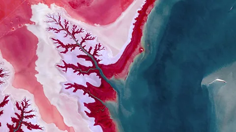
The Shadegan wetlands of south-west Iran cover about 400,000 hectares, making this the largest wetland area in the country. The wetlands are composed of a system of ponds, shallow lagoons and marshes, some of which form drainage patterns that resemble tree branches extending from cerulean stems.
Located in a fertile crescent of Iran, the Shadegan wetlands are surrounded by date palm orchards famed for their sweet dates, livestock farms and sugar plantations. Shadegan is also known for its biodiversity; the Shadegan Wildlife Refuge provides sanctuary to animals such as the marbled teal, a diving duck classified as vulnerable by the International Union for Conservation of Nature’s (IUCN) Red List of Threatened Species.
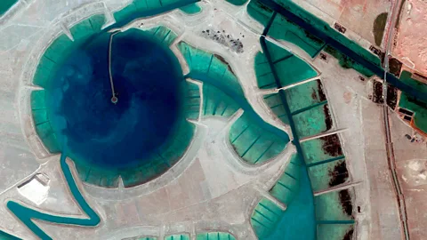
West of Abu Dhabi proper is Al Gharbia (or Al Dhafra Region), an area that from above resembles abstract artwork. Despite constituting most of the land mass of Abu Dhabi, Al Gharbia is sparsely populated and sits on the edge of Rub' al-Khali, known as the Empty Quarter, the largest continuous desert in the world.
Al Gharbia features some of the world’s tallest sand dunes, as well as eight desert islands teeming with wildlife. The largest of the islands, Sir Bani Yas, has been named the World’s Leading Sustainable Tourism Destination every year since 2014 by the World Travel Awards. Making up most of Sir Bani Yas is the Arabian Wildlife Park, home to more than 10,000 free-roaming animals such as giraffes, cheetahs, hyenas and gazelles.
The region is also known for holding the world’s only camel beauty contest, a two-week event that honours the fastest and most aesthetically pleasing camels in the region.

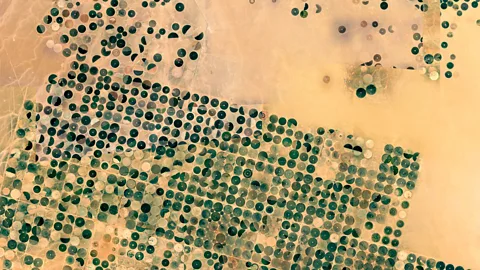
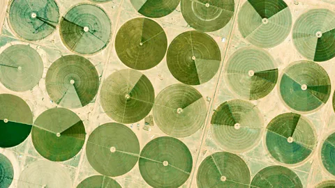
One could say that the Al Jouf region of northern Saudi Arabia is littered with reverse crop circles. However, rather than mysterious imprints on existing farmland, these circular swatches of land are actually meticulously planned plots of irrigated land on arid desert soil, creating a visual contrast of livelier green against the dusty sand colour in the image. These circular farms are crafted in a process known as centre pivot irrigation, which extracts water from deep within the land and launches it at crops from the centre of the fields. Fields vary in size and can reach up to 3km in diameter. The method has resulted in circular farms springing up all across the once-bare Saudi Arabian desert.
The Al Jouf Agriculture Project, which covers an area of 30,000 hectares near the town of Tabarjal, uses this centre irrigation method to produce wheat, barley, olives, tomatoes and other vegetables. It harvests rainwater, as well as water from the last Ice Age, that has been trapped under the land for several hundred thousand years due to shifting desert sands. The exact amount of water under this part of the desert remains unknown, but hydrologists estimate that the supply can last up to 50 years.
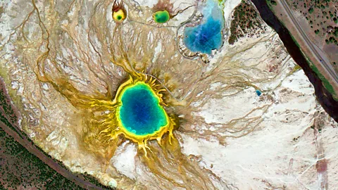
At 370ft in diameter, Yellowstone National Park’s Grand Prismatic Spring is the largest hot spring in the US and third largest in the world. When he first discovered it in 1871, American geologist Ferdinand Hayden wrote: “Nothing ever conceived by human art could equal the peculiar vividness and delicacy of colour of these remarkable prismatic springs.”
The hot spring gets its multicoloured rings – which are especially striking from an aerial perspective – from different species of bacteria that act like real-life thermographic photo filters. Each kind of bacteria thrives in a different temperature, their hues reflecting the various temperatures in different areas of the spring. At the center of the spring, the temperature can reach up to 87C, while the outermost, coolest ring sits at about 55C.
According to the Yellowstone website, the Grand Prismatic Spring is the park’s most photographed thermal feature.
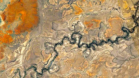
Snaking southwest through the parched Australian Outback, the Darling River (pictured) is the third longest river in Australia, extending more than 2,700km across south-east Australia.
Along its bank is the Darling River Run, a 730km scenic driving route that takes visitors to national parks such as the Mungo National Park and the Gundabooka National Park. The route also passes through Outback towns rich in culture and history. In Brewarrina, for example, explorers can find aboriginal fish traps estimated to be 40,000 years old, and the Willandra Lakes Region is the discovery site of the 60,000-year-old Mungo Man.
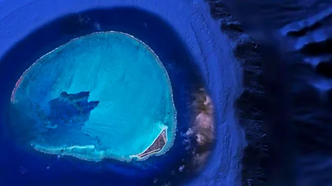
Kure Atoll is an oval-shaped coral atoll, the most remote of the Northwestern Hawaiian Islands. Located around 1,380 miles from Honolulu, Kure is part of the Papahānaumokuākea Marine National Monument, one of the largest marine conservation areas in the world. Green Island is the only island in the radiant atoll; there are no permanent residents living there.
Satellite images show a cyan blue ring, but to passing ships, the six-mile atoll is a mostly submerged and invisible danger. Some of Hawaii’s oldest shipwrecks were caused by and still remain on the atoll today, including 1870’s USS Saginaw and 1842’s New Bedford whaler Parker. More recently, in the 1980s, the Japanese whaler Hoei Maru ran aground on Kure’s reefs, and then broke in half due to severe weather. The front of the ship was carried by waves into the inner part of the atoll, where it still protudes from the water today.
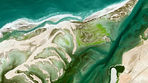
Home to fewer than 100,000 people, Umm al Qaiwain is the least populated of the seven United Arab Emirates. Despite boasting the largest water park in the UAE and historical sites that date back as far as 200BC, Umm Al Quwain mostly remains a collection of traditional fishing villages, and offers a quieter, slower-paced alternative to its bustling neighbour Dubai.
Seven islands are scattered across the coast of Umm al Qaiwain, each separated by creeks and replete with mangrove forests, vibrant lagoons and sand banks. The largest of the seven, Al Sinniyah (or Jazirat Mallah), is about 10km long and 4km wide, and from above, its shallow waters look like the bleeding shades of a blue watercolour and its sandy banks resemble thick, swirling brush strokes on canvas.
Half of the uninhabited island is dedicated to a nature reserve popular among birdwatchers for its diversity of species, which are attracted by its shallow waters. Conservation group BirdLife International lists Al Sinniyah as a ‘site of global importance’ for having one of the largest colonies of the threatened Socotra cormorant.
