The new Swedish hiking trail linking Stockholm to car-free island paradises
 Luke Waterson
When it opens to the public in October 2024, the Stockholm Archipelago Trail will link 21 islands and give Stockholm-bound visitors easy access to the nation's exquisite nature.
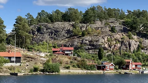
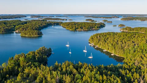
On my first boat trip out into the Stockholm Archipelago, the colour palette was vivid. The mirror-like shimmer of the labyrinthine sund (straits) divided up the green of densely forested islands, whose boulder-strewn shores were weathered to the hue of white gold. Fairy tale-like rust-red cabins peeped out of the trees or perched atop rocks. As my boat passed one such stretch of coast, another quickly hove into view, stretching to one horizon and then the next. This idyllic group of 30,000-odd isles and islets comprises one of the world’s largest archipelagos, with five times the number of Greek islands.
I was here to hike the newly created Stockholm Archipelago Trail (SAT), which opens to the public in October 2024. Connecting the archipelago from Arholma island at its northern end to Oja in the far south by waymarked paths for the first time – and becoming one of the world's only archipelagos to be linked end-to-end by trail – the SAT will open up the islands to the public like never before.
While the archipelago has been long used for leisure by boaters and beachgoers, the establishment of the 270km SAT sends the message out loud and clear that these islands are perfect for deeper exploration by foot. The route will run across 21 islands representative of the archipelago's abundant natural beauty, and in so doing will also showcase the need to protect its fragile ecosystems.
"We want to encourage everyone to walk here to raise the profile of the islands," said SAT creator Michael Lemmel. "Many people already come, but often use the islands in particular ways. For example, it is popular to visit by private boat, but those who do so will likely travel no more than 50m inland from the boat dock. The SAT [will] spread visitors out over a wider area than just, say, a marina."
 Getty Images
Lemmel and other proponents of the SAT believe the archipelago – a 1,700-sq-km span of tree-carpeted islands and rocky islets edged by sandy beaches and etched by skerry-peppered bays – has huge potential to redistribute the Stockholm region's influx of tourists more evenly. "The archipelago tourism window is very specific: an eight-week boom from late June to August and almost nothing the rest of the year," Lemmel said – but the walking season extends from May to September or October, meaning the route will take pressure off hotspots and peak visiting times.
Slowcomotion is a BBC Travel series that celebrates slow, self-propelled travel and invites readers to get outside and reconnect with the world in a safe and sustainable way.
Despite the archipelago being a regional highlight, a 2022 Visit Stockholm survey found that while 81% of overseas visitors to Stockholm sightsee in the city, only 26% take a boat ride out to see its islands. And there is so much to see and do there: basking on the beaches of Sandhamn and Nåttarö; kayaking across island-speckled bays; relaxing in remote cabins where views of sea, sky, forest and birdlife loom large through the windows; and, above all, soaking up the pervading sense of tranquillity that's harder to find elsewhere in the vicinity.
Visitors cannot bring cars across to the islands the SAT traverses, boats can only dock at certain points and the route is unsuitable for bikes, which makes walking the best way of getting around, whether that's for adventurers keen to trek the entire island-to-island route or more leisurely outdoor-lovers wanting to walk just the stages that appeal to them. Paths have been made welcoming with impeccable signage and strategically placed benches to take in the view. At the same time, the SAT's own environmental impact is negligible. Waymarks (blue for the sea, yellow for the sand) are attached to trees on removable bands so as not to permanently scar the trunk and the route follows pre-existing human and animal paths so new ones did not need to be cut.
"Making the trail is also a means for people vested in protecting the islands to subsist on the archipelago for much of the year," added Marie Östblom from the Stockholm Business Region, which is overseeing the trail's implementation. "Walkers will spur extra demand for sub-businesses like lodgings and localised tours. Most islands have few residents, so making important decisions about everything, conservation included, then becomes more efficient."
 Luke Waterson
In six days, I was able to hike the SAT across six islands – Finnhamn, Grinda, Sandhamn, Utö, Alö and Nåttarö – taking in more than a quarter of the entire route. So numerous are the islands and so thick the forest cover on most that locals say the only sure way to identify somewhere from the water is by the shape of its trees – but when I was on them, I found each island possessed distinctive traits.
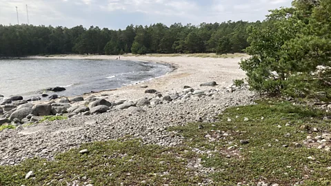
Finnhamn is the only archipelago island with oak trees, and huge rocky outcrops burst out of its forest floor, making for a thrilling hike. Grinda is a gentler mixture of forest and agricultural land. Both are nature reserves. Sandhamn is the most touristed island, yet the sandy pine forests stippling its south and west sides are serene and exquisite. Neighbouring Utö and the Ålö-Rånö nature reserve ratchet up the drama with deep skerry-strewn inlets and higher elevations that set up the archipelago’s finest panoramas. Meanwhile Nåttarö’s pine and birch fringed white sand beaches are unparalleled, and the island has become one of Sweden's first marine nature reserves.
Getting between the islands:
Each island on the route is linked by public ferry either to the next island on the route or to a mainland port, making access easy for those visiting Stockholm without their own transport. One trail stage on Nåttarö is just 30 minutes' voyage from mainland Stockholm commuter town Nynäshamn. Electrification of ferries serving the archipelago is beginning in 2025 too, rendering a visit to the islands an even greener proposition.
"We want to bring people out here to see these treasures for themselves," Lemmel said. "It's harder to care about conserving the islands without appreciating what they offer, and right now even Stockholmers don't know so much about them. We've got thousands of islands – some also on the SAT – that are wildernesses, within a short boat ride of a capital city. How many places can say that?"
Despite their natural beauty and their status as a wildlife bastion for seabirds, including Sweden's most significant sea eagle population, the archipelago is vulnerable to pollution. Its intricate web of waterways means polluted water from the Baltic Sea and from over-fertilisation in the Swedish river system can get trapped here. But this has often meant the archipelago has become a drawing board for developing long-term solutions to ecological threats.
On Utö, the SAT emerges from forest to encircle a man-made wetland home to a seminal scheme that, according to its creator Thomas Hjelm, can rejuvenate sea life across the entire Baltic. Through introducing top-level predator fish that had been fished to near-extinction like pike and perch and releasing them into the sea through the wetland, he has created a self-sustaining circulatory system. This decontaminates water within the fish's swimming radius of about eight kilometres, as these predator fish reduce algae levels. Wetland reeds grow quickly, too. When cut, Hjelm told me, they can make a viable alternative for fertiliser without the CO2 that turf-cutting, the standard means of creating fertiliser, releases.
 Getty Images
"This wetland is the blueprint to show others how it can be done," said Hjelm. "But several hundred of these around the Baltic seaboard would make a massive improvement."
The Sandhamn section of the trail is the busiest due to the popularity of the island's pretty port and beach. One of Sandhamn's main hotel owners, Lena Josefsson of Sandhamn Seglarhotel, told me that offering a sustainable travel experience was more challenging on the archipelago because of how basic services – recycling facilities and larger supermarkets, for example – were often located a boat ride away on the mainland.
More like this:
• An award-winning 1,400km hike into the wilds of Eastern Europe
"We've come up with a few schemes," she said. "We've just started to get all the food waste from our restaurant collected and made into fertiliser. Also, we're opening an off-grid retreat on a lighthouse offshore from Sandhamn. We hope this will attract a different type of guest, one with a lower carbon footprint."
As I walked the SAT, I took Lemmel's point about needing to see the archipelago to care about its ecological value. "Amazon" and "Arctic" are environmental trigger words: the Stockholm Archipelago is currently not. And this is what the trail does: it lets visitors experience the wonder of the trees giving way to a serendipitous beach or a silent inlet thronged by eider ducks; and, more importantly, it makes them think about why these things are so precious.
"And now is the best time to come," smiled Östblom. "Late August to October is our magic season. The summer crowds are gone but the water remains several degrees warmer than on the Swedish mainland."
And after six days of rugged hiking on the SAT, the water did look extremely inviting: millpond calm and tinged by golden autumn light. So in I jumped.
--
If you liked this story, sign up for The Essential List newsletter – a handpicked selection of features, videos and can't-miss news, delivered to your inbox twice a week.
