The Lagunas Route: A road trip through the roof of the Americas
 Michnus Olivier
Straddling two nations and stretching 400km through a surreal, Dalí-esque landscape, it's one of the loneliest and most eerily beautiful roads in the Americas.
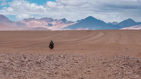
A small, makeshift booth with sheets of corrugated metal for a roof served as the immigration and customs office in the desolate, desert-like landscape separating south-west Bolivia from north-eastern Chile. Inside, two officers huddled around a kettle and a wooden desk sipping hot tea. After they stamped my passport, one of them suggested I look for 4x4 tracks if I got lost – I was about to enter one of the most remote corners of Bolivia, and I wouldn't see a paved road for hundreds of kilometres.
After thanking the border guards, I hopped back on my motorcycle and set off into the Eduardo Avaroa Andean Fauna National Reserve, a vast stretch of the Bolivian high plains along the Lagunas Route: one of the loneliest and most eerily beautiful roads in the Americas.
Stretching more than 400km from the town of San Pedro de Atacama, Chile, through the Bolivian Altiplano (the largest high plateau on Earth outside Tibet), the Lagunas Route is a network of gravel and sand tracks threading a landscape dotted with green, turquoise and red salt lagoons. Volcanoes, geysers and otherworldly rock formations crop up in every direction. The road is so remote it borders on desolate. There are few fuel stations, motels or services along the way, but it passes several small Indigenous communities before ending in the Bolivian town of Uyuni, whose salt flats are so vast they're visible from space.
 Michnus Olivier
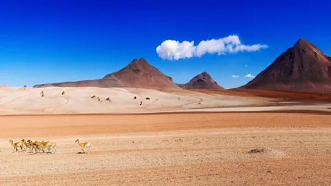
I was travelling more than 4,200m above sea level, and the high-altitude and cold, biting wind howling across the desert were dizzying. As I inched my way forward through the endless, empty landscape where flamingos, vicunas and Andean condors reign supreme, I struggled with mild altitude sickness, and the deep sand hugging my tyres made for slow going. Gusts of wind tugged relentlessly at the sparse tufts of grass and little dust devils danced across the shifting sands. Soon, I spotted a group of shy vicunas grazing in the distance – my only company for kilometres.
Making the trip
Depending on the weather (December to March is the rainy season in Bolivia), it can take anywhere from two to five days to complete the Lagunas Route, and travellers are advised to use 4x4 vehicles or off-road motorcycles. Food and lodging are available in Termas de Polques, and the towns of Villa Alota, and San Cristóbal; fuel is available at Villa Alota and San Cristóbal. Howlanders and Andean Ways offer 4x4 tours of the Lagunas Route.
In addition to being the highest and most isolated nation in South America, Bolivia has the largest proportion of Indigenous people, with roughly two-thirds of the population directly related to the area's original inhabitants. The nation is home to 36 recognised Indigenous peoples speaking 36 distinct languages, and throughout history, two of its largest ethnic groups, the Quechua and Aymara, have been the only ones to call this sparsely populated landscape home.
"Along the Lagunas Route, some of the Indigenous villages are so remote and secluded the locals do not speak Spanish – instead, children in schools are taught in Quechua. The communities are completely self-sufficient: people grow their own food like quinoa and potatoes (few other vegetables can grow at this altitude), raise llamas and alpacas for meat and have very little contact with the outside world," Remy van den Berg, who has lived in Bolivia for more than a decade and founded the El Mundo Verde Travel tour company, later explained to me.
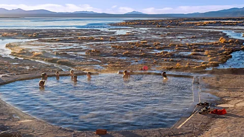
I soon experienced some of this for myself. After stopping at a small hotel by Termas de Polques, a natural hot spring whose mineral-rich waters hover at 29C, I exchanged a few basic words in Spanish with the women working in the kitchen.
 Alamy
Alamy"Chiri", one of the women said, smiling, as she handed me some heavy blankets. This was Quechua for "cold", and I'd hear it several more times on my journey. That night, after a lean dinner of boiled potatoes and sinewy meat, I fell asleep in a large room alongside a couple of French cyclists and a group of travellers in 4x4s.
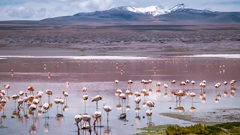
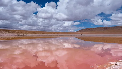
Rising early, I took one final dip in the hot springs to warm up, scraped the frost off my motorcycle and followed the Lagunas Route north. The 4x4 convoy had taken off earlier, and the French cyclists soon fell behind me as the Laguna Colorada came into view. A bright crimson expanse contrasting wildly with the salt deposits and desert mountains, this blood-red salt lake is home to flocks of flamingos strolling casually in its shallow waters.
Unlike the stunning Laguna Verde salt lake I'd passed the day before, whose bright emerald colour comes from arsenic, calcium and other volcanic runoff, Laguna Colorada's vivid hue is caused by red algae in the mineral-rich water. Although the landscape's biting cold wind, arid soil and thin air seem hostile to human life, the Lagunas Route offers breathtaking views with every kilometre. The aptly named Salvador Dalí Desert that separates the Verde and Colorada lakes is littered with surreal, wind-swept rock formations and the otherworldly turquoise and red lakes contrast against the white, pink and beige desert sands.
"The Indigenous people call this region Pampa Jara," said Saul V Enriquez Gutierrez, a Uyuni-based local guide. He explained that "jara" means "a place where shepherds rest", so this eerie, barren landscape is thought to be where nomad shepherds would stop while travelling long-distance.
 Alamy
AlamyThe Lagunas Route was originally used by locals in pre-Columbian times to transport goods between villages and settlements via llama caravans. In the 1890s, mining companies began using it to transport silver, zinc and salt to Chile. Gutierrez explained that over the years, the route's many natural wonders have become shrouded in legend. The blood-red Laguna Colorada, for instance, is said to have got its hue after being "touched by the devil", and anyone who drinks its water will die. Another local story claims it changes from red to green if it senses invaders, "but these are just stories people tell", Gutierrez said, smiling.
More like this:
As I travelled across the Jara, I heard more legends about this desert landscape. One afternoon, weary of dark storm clouds gathering over the horizon, I camped near an abandoned village made from crumbling abode mud bricks. Thunder echoed across the desert through the night, and in the morning, I noticed a few inhabited clay-brick houses a short ride away over a narrow creek. Hoping to buy some food, I approached and spoke to a woman tending to her chickens and sheep. Two small boys peered curiously at me from the doorway.
"See that stream over there? It used to be a river, but it runs dry now. The spirit of the mountain is angry because our village hasn't had a shaman for months now, and there's no one to cut the children's hair when they turn five anymore," the woman, named Rocio, told me with a sigh as she wrapped several wedges of fresh cheese in a cloth for me.
After fuelling up in the tiny town of Villa Alota, my final two days on the Lagunas Route were a muddy, slippery slog, thanks to the recent thunderstorm. As the contours of Uyuni came into view, I was dog-tired, cold to the bone and longing for a hot shower and a hot meal – but still found myself wishing the journey wouldn't end.
 Michnus Olivier
Perhaps it was route's kaleidoscopic lakes, the solitude and the breathtaking nature found on the roof of the Americas, but for five days, I felt like I was discovering some lonely, distant planet still untouched by the outside world.
The Open Road is a celebration of the world's most remarkable highways and byways, and a reminder that some of the greatest travel adventures happen via wheels.
--
If you liked this story, sign up for The Essential List newsletter – a handpicked selection of features, videos and can't-miss news, delivered to your inbox twice a week.
