Hurricane Lee weakens slightly to category four storm
Hurricane Lee has weakened slightly to a category four storm, but will remain powerful through early next week as it churns its way through the Atlantic.
It is packing wind speeds near 150mph (241km/h), and may bring "dangerous beach conditions" to the west Atlantic, the US National Hurricane Center (NHC) said.
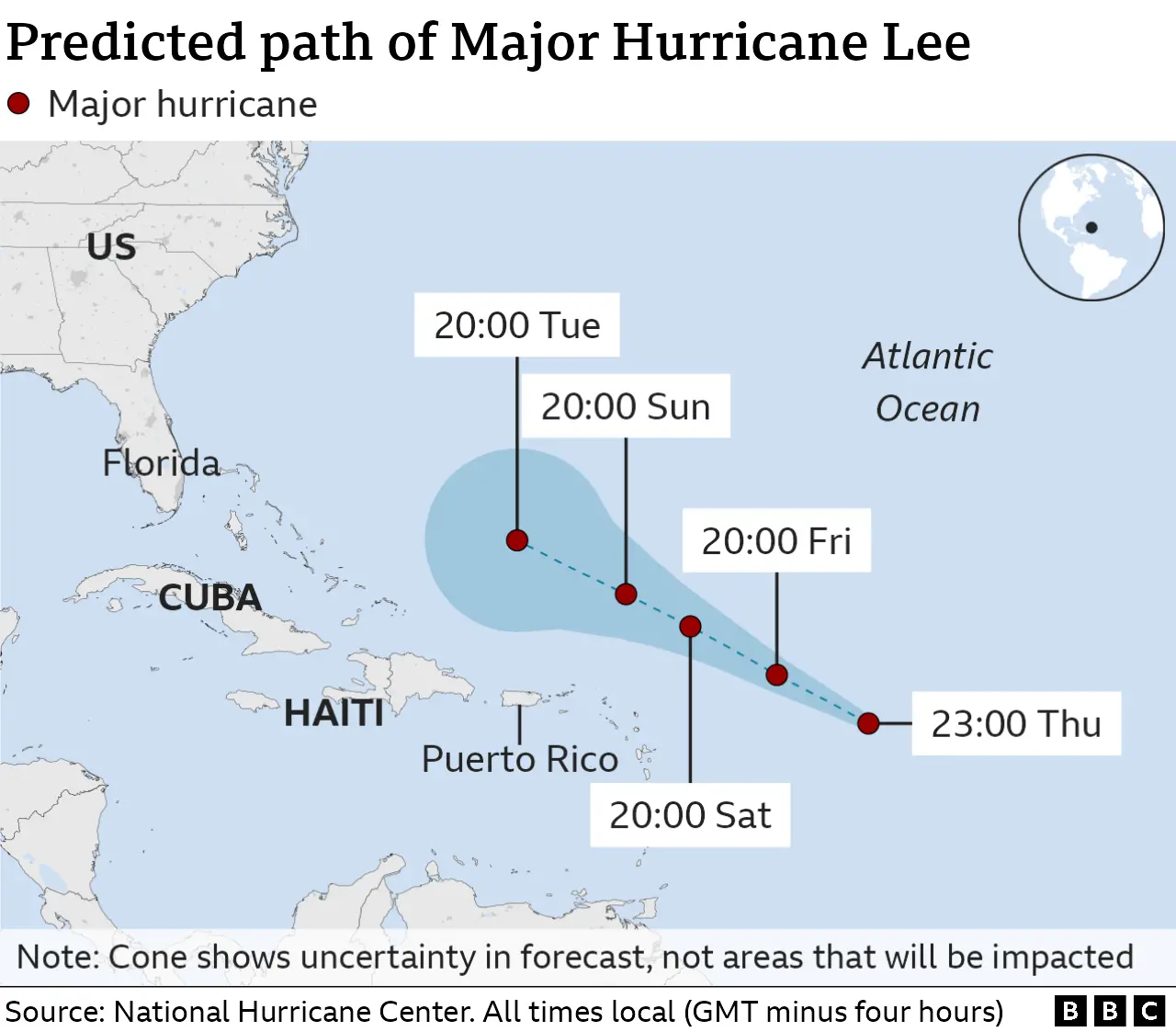
The storm is not projected to make landfall anywhere on its current path.
But its impact may be felt on the shores of some Caribbean islands.
Lee is the 12th named storm of the Atlantic hurricane season, which runs from June to November.
It rapidly intensified from a category one within the span of an hour on Thursday. At one point, Lee hit category five, packing wind speeds of up to 160mph (260km/h).
In its latest update, released at 17:00 local time (22:00 BST), the NHC said that the hurricane was expected to pass "well north" of the Leeward Islands, the Virgin Islands and Puerto Rico over the weekend and early next week.
While Hurricane Lee is currently not projected to make landfall anywhere, swells generated by the storm are expected to reach parts of the Caribbean - including the British Virgin Islands, Puerto Rico and the Turks and Caicos - beginning on Friday and through the weekend.
"These swells are likely to cause life-threatening surf and rip current conditions," the update added.
Similar conditions are expected to begin on the east coast of the US on Sunday, the NHC said on X, the platform formerly known as Twitter.
But the agency said it was too soon to say what effect the hurricane will have on the US, Atlantic Canada or Bermuda.
On Friday afternoon, Lee was located about 565 miles (910km) east of the northern Leeward Islands.
Meanwhile, Tropical Depression 14 became Tropical Storm Margot on Thursday.
Margot is projected to gain hurricane strength over the weekend, though it is expected to stay over open water.
Out in the Pacific Ocean, Hurricane Jova has weakened from a category five to two storm. It is expected to weaken further over the weekend over cooler waters.
Early on Friday evening, it was about 500 miles (805km) east of the Leeward Islands.
The 2023 Atlantic hurricane season is forecast to be more active than average.
The impact of climate change on the frequency of tropical storms is still unclear, but increased sea surface temperatures warm the air above and make more energy available to drive hurricanes.
As a result, they are likely to be more intense with more extreme rainfall.

