Taxis and buses used to track potholes
 University of South Wales
Taxis, buses and even delivery vans could soon join the fight against potholes.
They are the scourge of roads and motorists, with Flintshire council alone left with 4,000 and a £4m repair bill last year.
But special monitoring technology being developed at the University of South Wales (USW) could help to find potholes before they get worse.
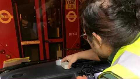
It works through a dashboard device that collects real-time data.
While sat-navs give the driver a profile of the road ahead, the small device records the profile of the road surface.
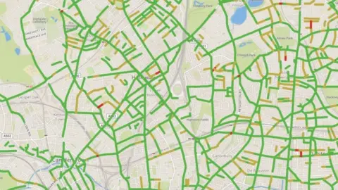
The system collects details of the smallest change in road vibrations, particularly potholes, feeding them into a real-time map.
If a vehicle is travelling the same route every day, data it gathers can highlight potential problem areas.
Trials have already been carried out with taxis and buses operated by Transport for London, highway maintenance vehicles in Northern Ireland and delivery cars working for Bristol Community Meals.
 University of South Wales
Data sent back shows the state of the roads, highlighted in red, amber and green to show their condition.
"The key problem councils have is knowing exactly where new problems form on the roads," said the man behind the device, Kevin Lee.
"There is ongoing planned maintenance. However that might not necessarily be where the roads are suffering the worst problems right now.
"So, if you don't know where the problem is, how are you supposed to fix it? The benefit of our system is that it records what the problem is, when it is actually happening."
Mr Lee is the managing director of Cardiff-based Mobilized Construction and is being supported to develop the system by USW's Centre of Excellence in Mobile and Emerging Technologies (CEMET).
 University of South Wales
He said the system solved the three main problems caused by failing roads: the fall in safety standards for motorists, cyclists, and pedestrians, the extra financial impact of road repairs and the environmental and time cost that road closures cause.
"The system gives local authorities time-relevant, vital data to ensure the roads that are in the most urgent need of repairs are dealt with faster," he added.
The RAC's Pothole Index found that in the first three months of 2018, the proportion of breakdowns caused by road surface problems almost doubled compared to 2017.
