How might Scotland's electoral map be changing?
 Boundary Commission for Scotland
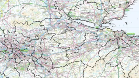
Plans for sweeping changes to Scotland's electoral map are being finalised, as part of a review which will see the country have two fewer MPs.
The Boundary Commission for Scotland has submitted its final recommendations to the Westminster parliament, and they are likely to be in place for the next general election.
How are these changes decided, and where are the biggest alterations likely to be seen?

Why is this happening?
Reviews of constituency boundaries are carried out on a regular basis, to keep track of population changes.
The idea is that MPs should each have roughly the same number of voters in their patch, so that representation is balanced fairly across the country.
This means the electoral map changes over time - for example, as cities grow and their populations swell, they get more representation in parliament.
MPs chiefly represent people rather than places, but changes can prove controversial given the importance people and indeed politicians invest in their places, particularly if they cut across historic communities.
There were three rounds of consultation while the current proposals were refined, with amendments - sometimes quite big ones - made in light of the comments submitted at each stage.
How are the changes decided?
 Getty Images
In a way, this is a simple question of mathematics.
You take the overall electorate of the UK and divide it by the number of seats - keeping aside a handful of protected island constituencies like Anglesey, the Isle of Wight and Orkney and Shetland.
That gives you an "electoral quota" of 73,393 - the target size of electorate for every constituency, give or take 5% on either side.
The only other rule is that no constituency can exceed 13,000 square kilometres (5,019 square miles).
Beyond that, it's down to an independent commission in each part of the UK to draw up specific proposals.
They take things like geography, local and historical ties and council boundaries into account - but really have a fairly tight box within which to work.
Some of the existing constituencies are now too big - Falkirk has 86,183 voters - while others are far too small - Glasgow North has 55,722.
So there is no option but to shift thousands of people into different constituencies to make the quotas fit.
Why is Scotland losing seats?
 Getty Images
We have known since January 2021 that the latest shake-up will change the number of MPs from each of the nations of the UK, on account of population changes - because it has grown more quickly in some areas than in others.
There is now a greater share of voters located in South East England in particular than there was when the current set of boundaries were drawn up - so to keep within the quotas, those people need an extra seven MPs.
The new boundaries will see England gain 10 seats overall - although some regions like the North East and North West will have fewer than previously - while Scotland will have two fewer, and Wales will lose eight.
There will likely be a political impact from this, because of the traditional power bases of the different parties located in different parts of the country.
The Conservatives would hope to do well from increased representation in South East England, while Labour could lose out if there are fewer seats in the northern areas of England, and Plaid Cymru are particularly unhappy about the drop in seats in Wales.
However, the changes have been drawn up entirely based on population changes and the calculation detailed above, and finalised by independent commissioners.
Where might the biggest changes be seen?
 Boundary Commission for Scotland
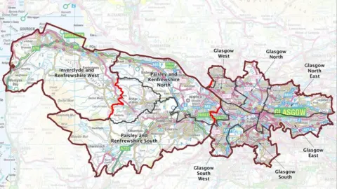
One of the disappearing seats is coming from Glasgow and the surrounding area, while the other is coming from the north of the country, between Aberdeenshire and the Highlands.
The former is probably the easiest to explain, with the current Glasgow Central constituency essentially being broken up and parcelled off into the city constituencies around it.
There are changes across the region though, which will go from ten MPs in total down to nine.
Inverclyde is to inherit the western chunk of Renfrewshire, while the old East Dunbartonshire seat expands north to become Mid Dunbartonshire.
On the other side of the city, a new Motherwell, Wishaw and Carluke seat is to spread out to the east, while Lanark will be split off to join Hamilton in a new constituency called Hamilton and Clyde Valley.
 Boundary Commision for Scotland
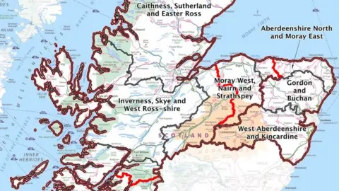
The old Moray constituency is to be cut in two, with Elgin joining a new Moray West, Nairn and Strathspey seat which spreads south down the A9 to Dalwhinnie.
The remains of the Inverness, Nairn, Badenoch and Strathspey seat is then extended right across to the coast, becoming Inverness, Skye and West Ross-shire.
The commission faced particular challenges in dealing with vast, sparsely-populated areas in the Highlands, but the tinkering with this area expanded right across to the east coast - the region as a whole going from having eight seats to seven.
The splitting of Moray will see Keith and Buckie move over into Aberdeenshire North and Moray East - a very coastal grouping which includes Peterhead and Fraserburgh.
The inland parts of the old Banff and Buchan constituency are to join up with the old Gordon one to create - no prizes for guessing - Gordon and Buchan.
If this is all getting a bit dizzying, maps of all the proposals can be found on the Boundary Commission website.
What else is changing?
 MOD
MODOrkney and Shetland and Na h-Eileanan an Iar are protected in law, and a handful of other seats are being retained in their present shape or only having a change of name.
But, otherwise, there are big changes right across the country - even beyond where seats have "disappeared".
Clackmannanshire has ceded Dollar to Dunfermline, with a new Alloa and Grangemouth seat spreading south across the Forth - but without including any bridges, meaning the local MP will need to nip into a neighbouring constituency to traverse their patch. Or buy a boat.
Broughty Ferry - which has long considered itself somewhat independent from Dundee - has been split off into a seat with Abroath, taking the Whitfield and Douglas areas of the city with it.
That leaves the remains of the city as Dundee Central, no longer split into east and west, while the leftover parts of the old Angus area will absorb most of the old Perth and North Perthshire patch to become Angus and Perthshire Glens.
Meanwhile in the capital, East Edinburgh will expand to capture much of Musselburgh from East Lothian - a move which has seen the latter constituency renamed "Lothian East".
This has raised some eyebrows with locals, but the commissioners say it was necessary because the seat no longer shares the boundaries of the local council - so the name has to change to avoid confusion.
When is it going to happen?
The last attempt at a boundary review actually would have seen Scotland lose six seats, as part of a move to cut 50 seats from the Commons.
It didn't happen in the end, because that whole review was scrapped by then-prime minister Theresa May.
The current set of proposals has made it to the Commons, and the UK government has four months to submit an order to the Privy Council to turn them into a reality.
Ministers are not allowed to change any of the recommendations without the approval of the Commissioners.
Once the Privy Council approves the order, the new constituencies take effect at the next election.
So unless there is a big change or a snap election over the next couple of months, it looks likely these changes will go ahead.
