COP26: How are road closures affecting Glasgow?
 Alamy
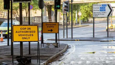
AlamyTravelling around Glasgow is expected to be "significantly impacted" during the COP26 climate change summit, with major road closures during the conference.
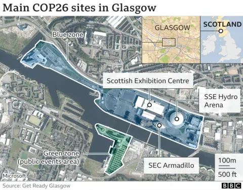
COP26 is held over two weeks from 31 October - 12 November 2021 at the Scottish Event Campus (SEC).
About 25,000 delegates are expected to be at the talks and security will be tight, especially around the attendance of about 120 world leaders.
How long are restrictions in place?
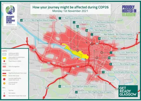
Road closures started a week ahead of the summit on 23 October and last until Monday 15 November.
Some days are expected to be busier than others. The biggest disruption is expected on Saturday 6 November, which has been designated as the Global Day For Climate Justice.
About 100,000 protesters are expected in Glasgow, with a march which begins at Kelvingrove Park at noon before making its way to Glasgow Green for about 15:00.
Transport Scotland, the national transport agency, has warned the public to avoid the SEC area and expect delays on the M8 as this will be the main route for delegates travelling to the summit.
The main message is to be prepared for anything. Unplanned protests could emerge, roads could be temporarily closed or diversions put in place at the last minute due to obstructions or for security reasons.
Get Ready Glasgow, the city's information site, has produced a congestion map to show where travel in the city will be affected.
It might not just be Glasgow that is affected, with world leaders staying in other locations such as Edinburgh, St Andrews and Perthshire.
Anyone who has to travel in central Scotland during the conference period could be affected.
You can read the official COP26 transport plan here.
Which roads are closed?
 Get ready glasgow
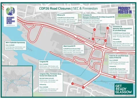
The area around the SEC summit venue will see the most impact. More than 9,000 people in Glasgow's Finnieston, Anderston and Yorkhill areas will be affected by parking restrictions and security measures.
Road closures will mean longer journey times, and businesses have been asked to carefully consider how their staff will travel to and from work on the busiest days.
The main closures are:
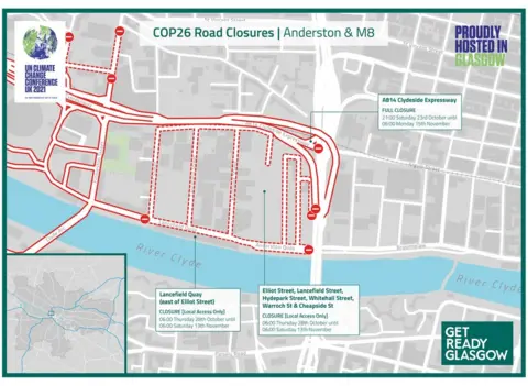
- A814 Clydeside Expressway The main route along Glasgow's riverside
- Clyde Arc Known locally as the Squinty Bridge
- Finnieston Street
The alternative routes are:
- Great Western Road
- Paisley Road West
- Clyde Tunnel
When will roads reopen?
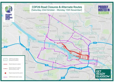
Get Ready Glasgow is suggesting motorists follow suggested alternative routes around the city until roads reopen after COP26.
Roads won't be back to normal immediately at the end of the summit. They will reopen gradually over the next week.
Congress Road - The main road outside the SEC campus will reopen on 17 November at 06:00.
Congress Way, Finnieston Quay, Tunnel Street, Stobcross Road and Castlebank Street - Subject to lane restrictions with full road closure until 06:00 on 21 November.
Clyde Arc, Lancefield Quay and Finnieston Street - Reopening on Monday 15 November.
Minerva Street - Reopens 13 November. Local Access to private car parks maintained.
Clydeside Expressway - The main route directly from the M8 motorway to the SEC summit venue. It reopens on 15 November.
How will motorway travel be affected?
The M8 and the M74 motorways are the most likely to be affected by closures and restrictions.
The main carriageway of the M74 on the approach to Glasgow will be extremely busy, where more traffic heads westbound towards the Clyde Tunnel alternative route.
Increased queueing and delays are also expected on the M8 at Junction 25 westbound as more traffic heads towards the Clyde tunnel. This is a key access road to the Queen Elizabeth University Hospital.
Transport Scotland has said there are no official requests to close any sections of the motorways. However this could change, and could be revisited in the event of individual incidents.
You can check day-by-day maps of road closures and diversions at Get Ready Glasgow.
Can I use public transport instead?
 Getty Images
COP26 delegates are being encouraged to travel by train to reach the SEC conference venue, which is served by its own station Exhibition Centre.
However, the RMT union has said members who work for ScotRail will strike during the summit, which is set to impact rail travel.
ScotRail says it has contingency plans to provide a core service for the duration of the summit.
Before these developments, Glasgow City Council and travel providers were working on travel demand management during COP26 and had already issued warnings that public transport will be very busy.
For delegates, a dedicated shuttle bus service will operate between Glasgow city centre and the SEC. Delegates are also expected to get a free travel smartcard, allowing them to use bus, rail and subway services in the city.
For city residents, the main advice is to plan ahead and allow extra time for unforeseen delays. The Traveline Scotland website has up-to-date information on all modes of public transport and a journey planner.
What about cycling in Glasgow?
Cycling is being highly encouraged during the climate change event.
Glasgow City Council's cycle hire scheme "Nextbike" will be free to use for all COP26 attendees to get around the city. It is also available to event volunteers and local residents.
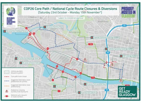
Glasgow has an expanding network of active travel routes and shared-use footpaths and a number of core paths connect the venue with the surrounding areas.
However, for security purposes, the National Cycle Network (Route 7), that runs north of the River Clyde to Loch Lomond, will be closed in Glasgow because of its proximity to the SEC venue.
Other cycle routes along streets and bridges within the summit zone are also closed to the public.
Where can I find up to date information?
For more information on what is happening please visit the COP26 website and Twitter feed
- For everything you need to know about how the event will affect Glasgow, visit the Get Ready Glasgow site and Twitter feed
- For live road updates, weather issues, journey planning and public transport information the Traffic Scotland mobile website my.trafficscotland.org and desktop website trafficscotland.org both offer a range of information services and the Traffic Scotland Twitter feed provides real-time updates on road issues
- Traveline Scotland is a source of public transport information and has a journey planning tool


