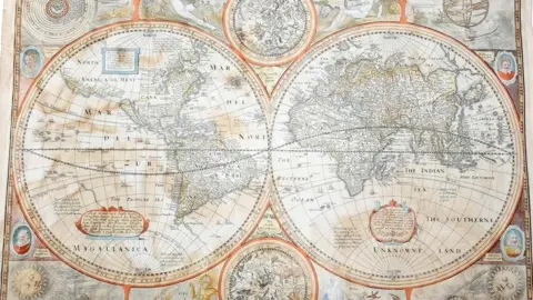
Rare world map found in Oxfam shop sells for £3.5k
 Woolley and Wallis
A 17th Century map discovered in "a shocking state" in a charity shop has fetched £3,500 at auction in Wiltshire.
The map of the world, which shows California as an island, was found "soaking wet" and in a broken frame by staff at an Oxfam shop in London.
After being dried off with a towel, the charity's valuer realised it was a rare map by renowned maker John Speed.
Expected to fetch up to £600, it sold for nearly six times its estimate at Woolley and Wallis on Tuesday.
Oxfam valuer Shelley Hitch, said it was in "such a shabby state" it could easily have been thrown away.
"Luckily our staff recognised the potential age of the map when it was dropped off," she said.
"The careful way it was dried means that despite its poor treatment it has raised a tremendous amount for Oxfam."
 Woolley and Wallis
Titled "A New and Accurat Map of the World", the map dates to around 1626 and was one of Speed's last big projects before his death in 1629.
Despite being in a poor condition and "stained from damp", the map was sold to a buyer in the United States.
"This is a rare map and highly desirable to collectors," said art specialist, Mark Yuan-Richards.
"The fact that the North American coastline is inaccurate based on what we know today gives a fascinating insight into how cartography developed through exploration and the establishment of trade routes."
Born in Cheshire, John Speed started life as a tailor, following in his father's footsteps, and only turned to cartography relatively late in life.
His talents were such that Elizabeth I granted him the use of a room in the Custom House for his work, and his maps continued to form the basis of all world maps until the mid 18th century and beyond.