Election 2017: The result in maps and charts
The Conservatives remain the largest party in the House of Commons on 318 seats, not quite the 326 needed to win an outright majority.
Theresa May's party lost 13 seats, while Jeremy Corbyn's Labour gained 30.
Overall results - the hung Parliament mapped
Select the "Changed seats" button below to see how the UK's political geography has changed overnight.
Details of all the 70 seats that changed hands are here.
Where the parties won and lost votes - change in vote share mapped
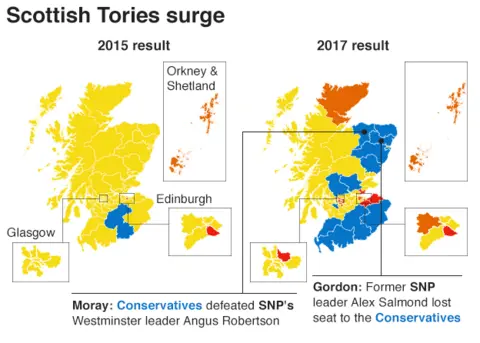
The Conservatives made striking headway in Scotland, where they gained a dozen seats. The party's vote share improved across most of the rest of the UK, but fell back in parts of the south east and London. These areas are shown in grey in the large map below.
You can see how Labour, the Lib Dems, the SNP, Plaid Cymru, UKIP and the Greens have done in the interactive map.
And what about Labour? Change in vote share mapped
Labour's share of the vote nationally rose by 10 percentage points to 40%, with strong performances across northern England, London, East Anglia and the south coast. The areas where Labour's vote share decreased are shown in grey below.
What happened in Scotland?
With the SNP winning a historic 56 of the 59 Scottish constituencies in 2015, the party had little room for improvement.
Instead, it lost 21 seats, with the Conservatives the biggest beneficiaries.


How do things look if all the seats are the same size?
Standard geographical maps tend to emphasise sparsely populated rural areas over urban seats, although all constituencies are of the same political value.
The closeness of the result is easier to see on a map with equally sized constituencies.
Map built with Carto using hexagons by Esri UK.
The return of two-party politics in England
While support for the Lib Dems in England dropped slightly, dwindled for the Greens, and fell off a cliff for UKIP, the combined vote share for the Conservatives and Labour is at its highest for decades.

"I believe it's only a temporary return to two-party politics," UKIP leader Paul Nuttall said as he announced his resignation.
Conservatives suffer losses in London
The Conservatives lost six seats in the capital, losing Battersea, Croydon Central, Enfield Southgate and Kensington to Labour, who saw its majorities increase in a number of constituencies.
The Liberal Democrats also made gains in London as former government ministers Sir Vince Cable and Sir Ed Davey both won back the seats they had lost in 2015 to the Conservatives.

Lib Dems wiped out in Yorkshire and the Humber
The Liberal Democrats lost both of the seats they previously held in the Yorkshire and the Humber region.
The most high-profile scalp came in Sheffield Hallam, where the party's former leader and former deputy prime minister Nick Clegg lost the seat he had held since 2005 to Labour.

Shifting sands in south-east England
The Conservatives suffered losses in the South East, losing six seats in the region, four to Labour and two to the Liberal Democrats.
Labour defeated the Conservatives to gain Canterbury, winning the constituency for the first time since it was formed in 1918.
Green party co-leader Caroline Lucas held Brighton Pavilion, increasing her vote share in the seat to above 50%.

Lost deposits
When a party gets less than 5% of the vote in a constituency, it loses the £500 deposit each candidate needs to put down to stand.
And in terms of lost deposits, some of the smaller parties in Westminster had disastrous nights.
While the Lib Dems increased its number of MPs, it lost its deposit in 375 seats. UKIP lost 337 deposits. But the party with the most lost deposits was the Greens, they only saved their deposit in 11 of the 466 constituencies they contested.
Party heartlands - vote share mapped
Labour's traditional strongholds stand out on the map below. With many seats in the north of England, south Wales and London showing Labour taking more than 50% of the vote.
You can see how the Conservatives, the Lib Dems, the SNP, Plaid Cymru, UKIP and the Greens have done in the interactive map.
Conservative strongholds - vote share mapped
This map is almost a mirror image of the Labour map above. With the Conservatives faring best in rural areas and in the south of England.
Where was turnout highest?
Turnout at this election was 68.7, over 2 percentage points higher than the 2015 general election. Turnout was up in 564 seats.
But although turnout has increased on average, the map below shows that it fell back in Scotland and some parts of England.
Map built with Carto using hexagons by Esri UK.
Nationally, more than half a million more people did not vote than voted for the Conservatives and the DUP combined.
And at a constituency level, non-voters outnumbered the people who voted for the winning candidate in 154 seats.

Produced by John Walton, Ed Lowther, Nassos Stylianou, Chris Ashton, Joe Reed, Alison Benjamin, Steven Connor, Luke Ewer, Prina Shah and Luke Keast.
