Scientists go airborne to understand soil erosion
 BBC
BBCA drone flies high overhead, gathering evidence of soil erosion in a Worcestershire potato field.
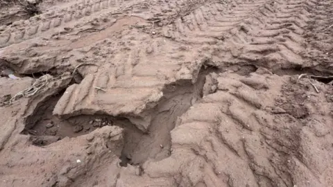
On the ground it is pretty obvious what’s happening, there is a huge crack running from the top of the field to the bottom, deep enough to swallow a boot at some points.
This erosion is caused by heavy rain and it is a problem that is getting worse according to farmer Alan Moule, who blames "the amount of rainfall we’re getting”.
As the climate changes, heavier downpours do more damage to the soil beneath, but for a farmer the question of how to tackle it is a difficult one.
Mr Moule has already taken several fields out of potato production, grassing them over for pasture instead.
Those grass roots will hold onto the soil and stop it being swept away.
But taking farmland out of production like this is a difficult decision.

However, new research by the University of Worcester may well help farmers work out what to do.
Josie Lynch, a researcher from the university, has been using a drone to take photographs of the fields and the erosion.
She has also taken soil samples and explained: “We can then work out what nutrients are being lost and then put a financial cost on it”.
It turns a difficult emotional decision into a financial one.

The work is being done in collaboration with Natural England and its Catchment Sensitive Farming project.
During a walk across Mr Moule's fields, James Griffiths from Natural England explained crops like potatoes were “high risk” when it came to erosion.
But being able to put a price on the soil lost, a cost that happens every time it rains, allows people like Mr Griffiths to make the case to farmers to try something else.
“To save some money and also have a knock on effect on the environment,” as Mr Griffiths puts it.
Because the more soil that is kept in the fields, the less ends up in our rivers and water courses, where it is often considered a form of pollution.
Follow BBC Hereford & Worcester on BBC Sounds, Facebook, X and Instagram.
