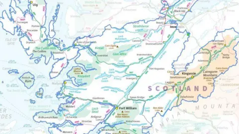
What would Scotland's new electoral map look like?

 Boundaries Scotland
A new political map of Scotland's constituencies and regions has been submitted to ministers ahead of next year's Holyrood election.
Boundaries Scotland has carried out its first review of the country's Scottish Parliament electoral geography since 2010.
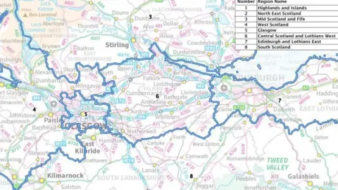
Holyrood will still have 129 MSPs, but there are changes to 45 of the 73 constituencies and seven of the eight electoral regions.
Scotland's population has changed as people have moved around the country, so the electoral map has to be refreshed to reflect that.
Trying to keep seats the same size - and thus having each MSP represent the same number of people - is a challenge given the diversity of Scotland's communities.
This is most notable in the Highlands, where minimal changes have been made to the vast existing seats. Caithness, Sutherland and Easter Ross stretches across 12,792 square kilometres, and still only has 56,732 voters.
Meanwhile Edinburgh Central crams 64,114 electors into just 11 square kilometres.
That reflects the fact Scotland's population is, over time, shifting east along the central belt.
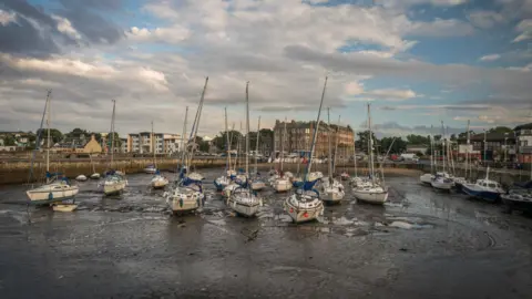 Getty Images
The population in the Lothians is growing at more than double the average rate across Scotland, so East Lothian makes for a good example.
More than 88,000 voters now live inside the council area, and each seat is supposed to have roughly 60,000 electors.
East Lothian simply can't just be one constituency any more, despite the protests of groups including the council itself.
So Musselburgh and Tranent have been chopped off, to go into a seat with Edinburgh Eastern.
That leaves East Lothian Coast and Lammermuirs as the remaining constituency, and local party strategists will no doubt be poring over ward-level polling to work out what that means for its electoral fortunes.
But here we come to another issue - the electoral regions, part of Holyrood's additional member system.
Given they carve the country into eight chunks, each electing seven list MSPs, they are necessarily enormous.
Under the present map, you could travel from Dunbar in East Lothian all the way to Stranraer on the west coast without leaving the South Scotland electoral region.
This obviously presents challenges for the politicians who are meant to represent these vast patches.
But with East Lothian now being divided between an Edinburgh seat and the new coastal constituency, it made sense to fold the whole council area into the Lothians electoral region.
Hence the creation of Edinburgh and Lothians East as a new region.
But that means something has to give elsewhere, and thus West Lothian has been parcelled off into a new region of Central Scotland and Lothians West.
Of course it isn't always possible to keep council areas intact - while 26 of the 32 are contained within a single region, the South Lanarkshire Council area has been divided between three.
Cue much confusion for aspiring MSPs based in Hamilton or East Kilbride about which regional list they should stand on.
 Boundaries Scotland
If this all sounds quite convoluted and confusing, spare a thought for the people responsible for coming up with the proposals.
The new map has been drawn up through a painstaking process of drafting, consultation and redrafting. In total there have been five rounds of consultation.
Boundaries Scotland start out with a quota which must be fulfilled - other than protected island seats, every constituency should have roughly 60,000 voters, and each region just over half a million - and then have to draw lines on the map which respect existing communities.
People often have deep roots to their local areas and thus strong feelings about anything which suggests changing how they are represented.
In the end almost 5,000 submissions were received, and nine independent "inquiries" were held to drill down into specific proposals in places like Falkirk and Paisley.
Those inquiries really did yield changes too. Returning to East Lothian, there was initially a plan to move Musselburgh into a seat with communities in the north of Midlothian, like Dalkeith, rather than those in the east of Edinburgh.
But after complaints from the council and locals about community ties, it was ultimately decided to move it into Edinburgh Eastern instead.
The strong feelings extend even to what the constituencies are called.
Officials originally wanted to have seats in Glasgow and Edinburgh named in terms of cardinal points - north, south, east or west.
There is a complicating factor in that it would be too confusing to have seats sharing a name with their Westminster equivalents, so Holyrood ones are normally "northern" or "western".
But there were complaints about the loss of traditional community links even just in the names. Some 750 people signed a petition demanding that "Leith" be featured in the local constituency title.
And so it was added back into Edinburgh North Eastern and Leith, and Glasgow's seats reverted back to name-checking the likes of Cathcart, Maryhill and Anniesland.
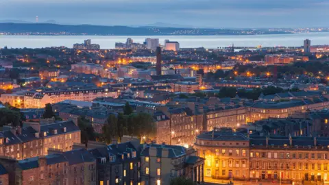 Getty Images
If approved by MSPs, the new boundaries will apply from next May's Holyrood election.
So they will not affect the Hamilton, Larkhall and Stonehouse by-election due to be held in June.
That seat is actually an example of how small some of the changes can be; the boundary is technically moving, but only with a tiny twist to follow the route of a burn through a wind farm.
No actual voters appear to be affected, but these kinds of changes do still sometimes need to be made to follow local ward maps.
The full set of maps can be found on the Boundaries Scotland website.
Many people may find themselves in a different patch compared to the previous three elections. Those in a new region might end up with eight new MSPs.
But ultimately it will still be down to them at the ballot box to decide who their representatives are next May.