Hurricanes are intensifying rapidly – this is what it could mean
 Getty Images
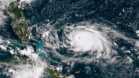
Hurricane Beryl, the first category five storm of 2024, marks an intense start to the Atlantic hurricane season. And it could be a sign of what is to come.
Hurricane Beryl, a category five storm, is the first hurricane of 2024 and the earliest category five storm in the Atlantic ever recorded by the US's National Hurricane Center.
The storm is unusual in more ways than one. Beryl strengthened from a tropical depression into a major hurricane – category three or above – in only 42 hours. It was classified as a category four storm within 48 hours, before swelling into a categery five storm as it headed towards Jamaica.
"It's rare to see a storm rapidly intensify this fast, this early in the season, in this part of the Atlantic," AccuWeather Lead Hurricane Forecaster Alex DaSilva told BBC News. And some experts fear it could be an "alarming" indication of what may be to come as the season progresses. The arrival of such a powerful hurricane in June has been attributed to the unusually high ocean temperatures, with the heat content of the seas around the Caribbean being more like the levels seen in mid-September rather than early summer, according to the World Meteorological Organization (WMO). It follows more than a year of record-breaking ocean temperatures.
The "unprecedented" growth in the strength of Beryl so early in the hurricane season "is in line with the recent trend towards very rapid intensification", says the WMO.
And this increase in hurricane intensity is a harbinger of the future, according to Jeff Masters, a meteorologist at Yale Climate Connections (a Yale University-funded climate media forum) and former NOAA scientist. "We should expect more cases of rapid intensification as the climate continues to warm."
Other recent hurricanes have intensified even more rapidly, all of which makes them hard to predict and prepare for.
In 2023, Hurricane Lee brought large swells and ferocious winds to batter the Caribbean islands. Experts saw the storm undergo a rapid change – quickly and unexpectedly intensifying into the highest category five strength. This dangerous pattern of hurricane behaviour is thought to be a sign of what's to come as the world's oceans warm up.
The hurricane, which reached 160mph (258km/h) winds on 8 September 2023, was a category one storm on Thursday but intensified to a category five, increasing by 85mph (137km/h) in just 24 hours. The increase made the hurricane, which meteorologists dubbed "rare", the third-fastest rapid intensification in the Atlantic. According to the National Oceanic and Atmospheric Administration (NOAA), the definition of rapid intensification is a 35mph (56km/h) over a one-day period – which Lee greatly exceeded.
Only two other Atlantic hurricanes in history have intensified more rapidly – Felix in 2007, and Wilma in 2005 – and only 4.5% of named storms in the Atlantic have grown to a category five in the past decade.
Some climate scientists were stunned in 2023 over not just Lee's sudden intensification – and then rapid weakening – but also the timing of Hurricane Jova, which rapidly ballooned into a category five storm as it made its way over the Pacific Ocean at the same time Lee was forming. These two huge storms formed as the US Atlantic hurricane season peaked on 10 September.
Hugh Willoughby, research professor at Florida International University's National Hurricane Research Center says a major hurricane intensifying rapidly isn't out of the ordinary, as that's just how they form – but it was especially surprising that these two did so during an El Niño.
 Getty Images
There's "pretty convincing evidence" that major hurricanes are becoming more common, says Willoughby, speaking to BBC Future Planet at the peak of the 2023 hurricane season.
Research has shown the proportion of tropical cyclones that reach category four and five is projected to increase due to global warming. Cyclones – or hurricanes, the term depends on their geographical location – form over warm sea surfaces; as water evaporates off the ocean's surface, it rises as humid air, creating an area of lower air pressure below, causing more air to rush in, which in turn warms and rises. The air that rises eventually cools, forming clouds and thunderstorms, and a system that spins and grows, fed by the ocean's heat and water evaporating from the surface. When wind speeds reach 74mph (119km/h), they're classed as a hurricane or cyclone.
Since industrialisation, humans have been fuelling the rapid rise of greenhouse gases, which have increased the frequency and intensity of extreme weather events. And the costs, both on human life and the economy of extreme weather events, are rising.
You might also like:
"What we need to worry about are storms that become major hurricanes becoming more frequent and doing more damage," adds Willoughby. "We have every reason to expect them to become more common, and it's going to get worse."
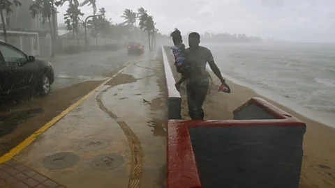
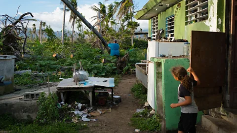
When hurricanes make landfall they begin to decrease in strength because they no longer gain energy from the ocean. However, they can still wreak devastation. When Hurricane Maria, a category five storm, hit the northeastern Caribbean in 2017, it killed as many as 4,600 people in Puerto Rico alone, causing power cuts, broken roads, and knocking out water services. It was the strongest hurricane to hit the island in a century.
In the Northwest Pacific, Hurricane Patricia, which hit in 2015, was the strongest landfalling Pacific hurricane on record. It was also the strongest storm in terms of wind speed, with winds of 214mph (345km/h). The death toll, almost unbelievably, was zero. The strongest Atlantic hurricane by wind speed was Hurricane Allen in 1980, which caused nearly 300 deaths in Haiti and whose winds reached 190mph (306km/h).
Economic harms – and billion dollar disasters – caused by extreme weather events are becoming more commonplace. Hurricane Katrina remains the costliest hurricane on record. The 2005 event, which destroyed more than 800,000 homes and brought catastrophic flooding to Louisiana, is estimated to have cost the US $193.8bn (£155bn).
 Getty Images
Although the Atlantic and Northeast Pacific have their fair share of hurricanes, one of the most active tropical cyclone basins is in the Western Pacific, where there are warmer sea surface temperatures, which cyclones need to thrive. The strongest tropical cyclone ever recorded worldwide – measured by the storm's central pressure – was Typhoon Tip in 1979, which reached wind speeds of 190mph (306km/h) and killed 99 people, mostly in Japan.
The deadliest cyclone, however, happened in 1970, caused between 300,000 to 500,000 fatalities in what is now Bangladesh. The deaths were mostly caused by a large storm surge which overwhelmed the low-lying islands and led to the United Nations calling for ways to mitigate the harmful effects of tropical cyclones.
Although some scientists say it is too early to correlate rising ocean temperatures with an increase in hurricanes and cyclones, warmer waters do intensify wind speeds – making these storms more dangerous if they make landfall.
"It's unclear at the present whether the recent years of increased storms constitutes a trend," says Jordan Gerth, research meteorologist at the Space Science and Engineering Center in Wisconsin. He notes there have been a greater number of named storms than the historical average, but that this may be due to improvements in the quality of meteorological observations, including NOAA upgrading its satellite system and forecasting models.
"However," he continues, "due to increases in water temperature, a primary source of fuel that can increase the intensity of hurricanes, we expect, and are witnessing, an increase in the number of major hurricanes. In other words, a hurricane is more likely to intensify in today's climate than in years past."
Despite slowing down over the weekend to a category four, Lee is expected to cause "hazardous beach conditions" around the US East Coast, Bermuda, and the Bahamas throughout the coming week. Experts at the National Hurricane Center also predicted the hurricane would grow in size again over the coming days, but that it was still too soon to know the level of impact, if any.
"What we can learn from these storms," Gerth warns, "is more socioeconomic than meteorological. US infrastructure and communities are vulnerable."
* This article was originally published on 12 October 2023. It was updated on 2 July 2024 to include details about Hurricane Beryl.
--
If you liked this story, sign up for The Essential List newsletter – a handpicked selection of features, videos and can't-miss news, delivered to your inbox twice a week.
