How aircraft conquered Antarctica
 Vittoriano Rastelli/Getty Images
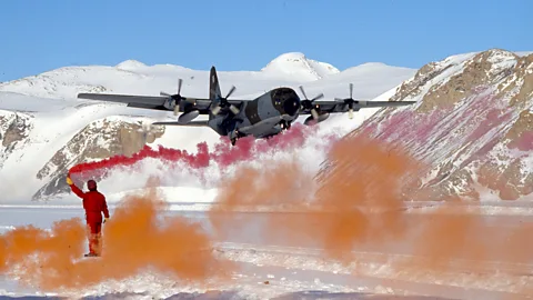
Flying on the coldest continent on Earth is a dangerous business, but without aircraft we would still know relatively little about Antarctica and life there would be impossible.
The heroic age of Antarctic exploration reached its zenith in December 1911, when Norwegian Roald Amundsen beat Robert Falcon Scott to the South Pole. It ended, arguably, at 8.20am on 20 December 1928, when Australian Sir George Hubert Wilkins took off in a "sleek, shiny, bullet-shaped" high-wing monoplane from Deception Island, just off the Antarctic Peninsula, to explore the last great hole in the map.
With that flight, the machine age of Antarctic exploration had definitively arrived – the flying-machine age – and arguably, we are still in it nearly a century later. There are around 50 runways in Antarctica, and Australia is hoping to build a new concrete runway.
Wilkins's flight was followed by similar flights by early aerial pioneers such as Richard Byrd, aviators divided by feuds but who were as brave as their muscle-powered predecessors. Their expeditions paved the way to the demilitarised, environmentally protected, and science-led Antarctica we have today, even if it is, perhaps, not the one they wanted.
"The pioneers like Wilkins were hugely courageous aviators," says Victoria Auld, a pilot with the British Antarctic Survey (BAS). "We have GPS and radio, but they would set out on long flights to the pole with only a sextant to estimate their positions with, and a lack of, even basic communications equipment."
Like elsewhere in the world, even in the early days of Antarctic aviation, aircraft completely transformed what explorers were able to achieve.
"The plane was the real game changer because you can cover so much ground so quickly," says Klaus Dodds, professor of geopolitics at the University of London Royal Holloway, and author of The Antarctic: A Very Short Introduction.
But aircraft also gave explorers an entirely new perspective on the Antarctic continent that allowed them to see just how vast it really was.
"Wilkins and Byrd were the first people to systematically fly over Antarctica," says Adrian Howkins, a reader in environmental history at the University of Bristol. "When you look at the maps they produced you can see just how much of the continent they were able to see from a plane, rather than a ship or walking across the ice. But making sense of what they saw wasn't as easy and some mistakes were made."
 Bettmann/Getty Images
Antarctica may now have been mapped by satellites, but it doesn't mean that humans have been everywhere, or that the maps have always been updated. "Sometimes mountains would be marked on the very basic maps that we had," says polar explorer Felicity Aston, a former BAS meteorologist, author, expedition leader and, in 2012, the first woman to ski alone across Antarctica. "Sometimes they wouldn't be, and suddenly you were flying over a whole mountain range when on the map there was a bit of text in the middle of a large, blank white area, that said, mountain spotted here in 1967."
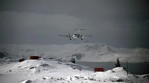
Auld now flies the high-wing, twin-engine de Havilland Twin Otter. The Twin Otter is a mainstay of the BAS "air force" because of its toughness, reliability, and ability to take off from, and land on, short runways.
Typically, she is "flying survey lines" above a particular spot to investigate geophysics or atmospherics in that location, or on week-long trips to instrument sites in the "deep field" to download data, carry out repairs and set up new instruments.
"Some of the older guys would say there is no more real flying these days," says Auld. "But there's not many jobs, certainly for a UK pilot, where you can go and land on snow on skis in an aircraft.
One of the greatest dangers pilots face in Antarctica is disorientation due to a lack of contrast between the sky and the land. To prevent this danger, BAS won't deploy an aircraft to a new site unless there is "sunshine on the ground" [clear blue sky].
"When we go deep field into mountain sites, we'll have a good look at the landing site from overhead from many different angles to spot crevices," says Auld. "Then assuming we can't find any, we use a technique called trailing ski to put sufficient weight on the skis to test to see how rough the surface is, but also to see if we're exposing any crevices that we couldn't see from the air. If we're happy with that, then we'll come in and land."
In Antarctica it pays to think about the what ifs. "We are always thinking about our go-around pattern and making sure we're not exposing ourselves to a situation where you can't get away because of rising ground ahead of you," she adds.
Auld finds herself talking increasingly with drone pilots, working out how to blend operations of the Twin Otter with the Remote Piloted Aircraft Systems (RPAS) that the BAS is developing.
In 1928, the bullet-shaped aircraft that Wilkins and his co-pilot Carl Ben Eielson flew was the cutting-edge craft of its day. Their Lockheed Vega was designed by Jack Northrop, who later founded the Northrop Corporation, famous for the B-2 Stealth Bomber. Earlier in the year, in another Vega, the two pilots had become the first to cross the Arctic Ocean from Alaska to Svalbard, Norway.
On the opposite side of the world, the explorers raced above the Antarctic Peninsula. In just 20 minutes, the Vega covered 40 miles (65km), a distance that would have taken months to traverse on foot. After nearly 4.5 hours, with half his fuel spent, Wilkins opened a hatch, dropped a proclamation (a flag and document) claiming the land for King George V of Great Britain, and reluctantly turned back.
In the 10-hour flight – filmed by two movie cameras on board – the Australian and his American colleague had crossed at least 1,000 miles (1,600km) of previously unrecorded Antarctic territory. During the flight they were able to get a view over 100,000sq miles (258,998sq km) of Antarctica, according to estimates from the time. Wilkins named the bays, land and mountains he discovered after his supporters: Hearst Land, Mobiloil Inlet and Lockheed Mountains. "For the first time in history, new land was being discovered in the air," he wrote.
From his flight, Wilkins mistakenly concluded that the Antarctic peninsula was three islands rather than an extension of the mainland.
You might also like:
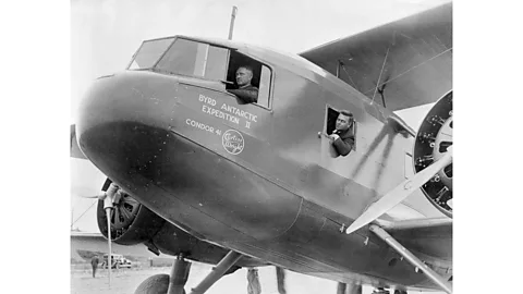
But the Australian soon had company in Antarctica. In January 1929, American explorer Richard Byrd's "million-dollar expedition" had arrived in the Bay of Whales, near Scott's base for his ill-fated expedition. This was the largest expedition yet sent to Antarctica, and with it came three aircraft and the men to build an underground base in which to overwinter. It was named Little America, and three radio antennae marked its spot. A large slice of Western Antarctica was named after Byrd's wife, Marie Byrd Land.
Wilkins's arctic flight had been a triumph, but many doubted that Byrd had flown to the North Pole two years earlier as he claimed. Now the American had to beat his rival to the South Pole, but he lost nerve. He feared that his Trimotor was too heavy, unreliable, and thirsty for such a flight.
The winter months gave Byrd a brief respite, but by November 1929 Wilkins was on his way back to Antarctica, and Jack Northrop told the newspapers that "we will see a race between Wilkins and Byrd". Byrd also knew that an Australian expedition led by Douglas Mawson was on its way to explore from the coastline around Enderby Land by air to claim it for Britain, and a Norwegian expedition was heading to roughly the same area, to use the same method. Among them was explorer Ingrid Christensen, who became the first woman to see Antarctica, fly over it, and maybe even the first woman to set foot on the Antarctic mainland.
So, at 3.30pm on Thanksgiving Day, 28 November 1929, Byrd took off for the South Pole and headed out into the polar wasteland.
The plane raced across the Ross Ice Shelf, and then laboured to climb up the Liv Glacier to the High Polar Plateau and the pole, but the glacier brought them face to face with a giant ice wall that appeared to be at least 1,500ft (500m) too high for the aircraft to fly over.
Desperately they cast their supplies out of the plane until, at the last minute, close to the ice wall, an updraft picked them up and threw them over the top.
Ten hours later, at 1am on 29 November 1929, Byrd reached the South Pole and dropped the US flag. Wilkins made several further flights, but none came close to rivalling Byrd's achievement.
Then on Christmas Day, tragedy struck: another Norwegian aviator took off on a short flight, a storm blew up and was never seen again.
 Vanderlei Almeida/AFP/Getty Images
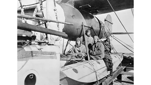
In January 1946, Admiral Richard Byrd ordered the brand-new aircraft carrier Philippine Sea to turn into the wind and six huge propeller-powered long-range Douglas Skytrain cargo planes were blasted into the sky by rocket packs for an eight-hour flight to the Bay of Whales, at Antarctica's Ross Ice Shelf.
The 13 ships, 33 aircraft and 4,700 men of the US Navy's Operation Highjump made it the largest expedition ever sent to Antarctica, the apex of the conquest by Antarctica by air, and the birth of a new era of science-led exploration. The goals of the massive expedition included naval preparedness for Arctic warfare; mapping the coastline of Antarctica; assertion of American territorial sovereignty over around 40% of the continent and scientific research. The expedition would climax with a rerun of Byrd's 1929 flight to the South Pole. At the end of which, he dropped the flags of the United Nations over the Pole.
Byrd and his men made many new discoveries. Yet, without ground markers, many of the photographs his men took were useless, and by 1955 only about a third had been used for mapping.
For Dodds, exploration is "never neutral", and that was certainly true of Wilkins, Byrd, and their kind. These men were motivated variously by personal challenge, discovery, wonder, science, and glory, but also by imperialism.
"In the 1920s, 30s and 40s there were mapping wars because the ownership of Antarctica was disputed," says Dodds, "and what these countries were trying to do was to draw and publish as many maps of Antarctica as they could, in as much detail as they could, to establish their claim to it."
The "mapping wars" led to the aviators on the 1939 German expedition dropping metal arrows emblazoned with the Nazi Swastika out of their flying boats to mark their land claim. Needless to say they weren't particularly effective, but this didn't stop Germany claiming a "vast Antarctic territory". Following its defeat in the World War Two, Germany had to renounce any claims to Antarctica.
What drove this land grab was whaling and the need to control the waters around Antarctica. Coal, oil and, later, uranium were next on the list, but no one really knew what was under the ice. It was suggested in 1940 that coal dust could be used to melt the ice, and after the war, nuclear bombs.
Yet Antarctica wasn't carved up by the great powers. Instead, a new era of scientific exploration began to emerge. In 1955-56, Operation Deep Freeze saw the US Navy turn its attention to supporting American scientists on the scientific exploration of Antarctica. On 31 October 1956, the U.S. Navy did what many thought impossible, and landed a LC-47 Douglas Skytrain airplane at the South Pole. The following year brought an unprecedented programme of scientific collaboration under the International Geophysical Year (IGY) of 1957–58, which in Antarctica involved the scientists from around 70 nations.
This new focus on science also brought more women to the continent. In 1968, at the age of 72, Argentinian Irene Bernasconi became one of the first woman scientists to work on the continent – following in the footsteps of Jackie Ronne, who in 1947, became the first woman to explore Antarctica as a working member of an expedition, and who along with Jennie Darlington became the first women to overwinter in Antarctica. Ronne would return a total of 15 times to the Antarctica, including on a US Navy-sponsored flight to the South Pole in 1971.
By far the most important achievement to emerge from the endeavours of the IGY was the Treaty of Antarctica, which was signed in 1959 and committed 12 nations to a demilitarised, peaceful continent based on the principle of international scientific cooperation. That number has now swelled to 46 nations.
"Aviation also helped to confirm the ice-covered nature of Antarctica, which arguably contributed to a willingness to compromise in the Antarctic Treaty because there was little immediate prospect for economic gain," says Howkins.
Science has become the "currency" of the continent, and building infrastructure, like runways, keeps it flowing by allowing aircraft to continue to arrive..
"Antarctica runs by air," says Felicity Aston. "Shipping is important, but it is due to all those early aeronautical expeditions of the 1920s and 1930s, that we have all those air logistics that are so vital to the science programmes, as well as the tourism and the exploration in Antarctica."
 Bettmann/Getty Images
"Aviators such as Richard Byrd were hugely influential in firing the geographical imaginations of the publics [around the world]," says Dodd.
The movie With Byrd At The South Pole won an Oscar for its cinematography. His book Alone is one of the classics of polar literature. The movie about Operation High Jump - The Secret World – won an Oscar for best documentary
Yet, tensions remain. The Antarctic Treaty has merely frozen territorial claims rather than resolving them, and many countries like Russia and China want their place on the ice. And the melting ice sheet is threatening to trigger new disputes over the territories by making it easier to mine the mineral wealth buried beneath.
"Surveying to reveal the location of valuable resources is banned by the treaty," says Felicity Aston. "But it's highly improbable that with all the geological surveys going on that scientist don't already have a pretty good idea where the resources are." And there is powerful lobby working to allow mining on the continent.
Also, the air forces of many nations still make their presence felt on the continent through operations to support scientific research.
But flying is still dangerous in Antarctica. In 2019, a Chilean Air Force C-130 Hercules crashed with the loss of 38 passengers and crew after the aircraft broke up in flight, or on hitting water. The cause of the crash is unknown.
That said, it can now take as little two weeks for a scientist to leave their home comforts and be deployed in the field, "massively extended the working seasons of the science teams", says Rodney Arnold, the head of the air unit at the British Antarctic Service, and allowing organisations like his to attract a wider range of scientists to the continent.
Douglas Dakota-Skytrains still do much of the heavy lifting, and remanufactured as the Basler BT-67, demand for these tough American heavy lifters is increasing. Some, renamed as Snow Eagle 601, can even be found in the colours of China.
Now with the coming of the drones, and if built, the new Australian concrete runway could lead to all-year-round flights. It may mean much more of the frozen continent is explored from the air.
* Mark Piesing is the author of N-4 Down: The Search for the Arctic Airship Italia, the true story of the largest polar rescue mission in history.
--
If you liked this story, sign up for the weekly bbc.com features newsletter, called "The Essential List". A handpicked selection of stories from BBC Future, Culture, Worklife, and Travel, delivered to your inbox every Friday.
